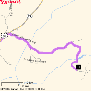
Map and Driving Directions to Camp
Maubila from Mobile, Alabama
|
Starting from: |
 Mobile, AL
 |
|
Arriving at: |
 Camp Maubila, Grove Hill, AL 36451
|
|
| Distance: |
Approximately 75 miles |
Approximate Travel Time: |
2 hours |
|
|
Camp Maubila Road
|
|
|
| 1. |
Starting in
MOBILE, AL proceed North on US-43 - go
approximately 60 miles |
| 2. |
Continue on
US-43/US-43 BYP - go 5.0 mi |
| 3. |
US-43/US-43 BYP becomes US-43 - go 4.4
mi |
| 4. |
Turn
 on CAMP MAUBILA RD - go 3.8 mi
|
| 5. |
Arrive at
CAMP MAUBILA - The entrance is on the North
(left) side of the road. |
When using any driving directions or map, it's a good idea to do a
reality check and make sure the road still exists, watch out for
construction, and follow all traffic safety precautions. This is
only to be used as an aid in planning.